Discover Wild Manitoba
Find the best free camping spots and outdoor activities on Manitoba crown land
Explore Map Which land is which?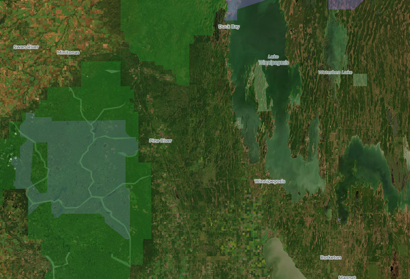
Reading the Manitoba map
Manitoba does not publish open parcel-level Crown land data, so the map shows the designated areas it does publish. Land with no colour is often plain Crown land, especially north of the agricultural belt, but not always. How to confirm a spot
Crown land in Manitoba: what you need to know
Where the Crown land actually is
Manitoba splits cleanly in two. South of the Canadian Shield, from the Red River Valley west through Portage la Prairie, Brandon and the Pembina Valley, most land is privately owned farmland. Public land there comes in islands: provincial forests like Sandilands, Spruce Woods and Agassiz, Wildlife Management Areas scattered among the fields, and agricultural Crown land leased for grazing or hay, which is not open for camping just because the province owns it.
Cross into the Shield east of Lake Winnipeg, or drive north past Grand Rapids on PTH 6, and the picture flips. Most of that country is Crown land, much of it with no park or forest designation at all. That is why large parts of the map look blank up north. Blank there usually means undesignated Crown land, not private property. Our Crown land by city pages show what is realistically within reach of each town.
Camping on it
Camping away from a developed campground on unoccupied Crown land is common in Manitoba, especially in the Shield and the provincial forests. It is not a free-for-all. Leased land, cottage subdivisions, mining and forestry operations, and land with a First Nation or community interest all come with their own limits, and provincial parks restrict camping to designated sites.
Fire is the rule that catches most people. Manitoba prohibits open fires from April 1 to November 15 except under a burning permit or in an approved enclosed fire pit, and the Manitoba Wildfire Service can add area travel and fire restrictions on short notice in dry summers. A cleared ring of rocks on a Crown land point does not count as an approved pit. Our Crown land camping rules guide goes through what the province expects of campers, and where to confirm it.
Parks, provincial forests and WMAs are not the same thing
The colours on the map stand for different rules. Provincial parks (purple) are run by Manitoba Parks: you need a park vehicle permit to drive in, and camping happens in campgrounds or designated backcountry sites. Provincial forests (green) are Crown land managed for timber, wildlife and recreation, and they are where a lot of informal camping, berry picking and hunting happens. Wildlife Management Areas (olive) exist for wildlife habitat. They are open year-round with no entrance fee, and hunting and trapping are generally allowed, but vehicles and some activities can be restricted and some uses need a WMA use permit.
Refuges and Special Conservation Areas carry tighter limits, and national parks like Riding Mountain follow federal rules entirely. The guide to parks, forests and wildlife areas lays out the differences side by side.
Confirm before you go
Manitoba does not publish an open map of every Crown parcel, so no website, ours included, can promise that a given shoreline is open Crown land. Use the map to narrow your options, then check. Look for leases, cottage lots and road allowances, and treat the gold layer, which marks Treaty Land Entitlement and community agreement lands, as a reason to contact the First Nation or community first. Our how to find Crown land guide walks through the checks.
If you plan to fish, every angler needs a Manitoba Angling Licence unless exempt, and barbless hooks are mandatory across the province; see the fishing licence and rules guide. Hunters should start with hunting on Crown land, then read the current Manitoba Hunting Guide.
Manitoba guides
The rules for camping, fishing and hunting on Manitoba's public land, each checked against the provincial source it links to.
Explore Manitoba
Crown land by region
BorealMaps: the app that reads your geo-referenced PDF maps
Export a map here, open it in BorealMaps on your phone, and your GPS position shows up right on it — with no cell signal at all.

Plan Your Next Road Trip
The Itinerary Planner lets you draw any route on the map, split it into segments, and instantly generate offline-ready geo-referenced PDF maps for every leg of your journey.
Try the Itinerary PlannerDownload PDF
Generate geo-referenced PDF maps with your selected areas and custom markers for offline use.
About See plans