Discover Wild New Brunswick
Find the best free camping spots and outdoor activities on New Brunswick crown land
Explore Map Which land is which?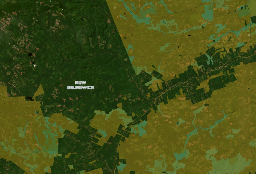
Reading the New Brunswick map
Unlike most provinces, New Brunswick publishes its Crown land itself, so the yellow parcels are public land and the unshaded ground is mostly private woodlots, industrial freehold forest and farms. Yellow tells you who owns the land, not what you may do on it, so read the posted signs and the day's burn conditions before you set up camp. How to confirm a spot
Crown land in New Brunswick: what you need to know
Only about half the woods are public
Forest covers most of New Brunswick, but only about half of it is Crown land. The rest belongs to tens of thousands of private woodlot owners and to forest companies that own large blocks of freehold forest. Crown land is concentrated in the north and the central highlands: the Restigouche uplands, the country around Mount Carleton, the upper Miramichi and the big tracts between Plaster Rock and Bathurst. Near Moncton, Saint John and Fredericton, the nearest Crown land is often a short drive away rather than next door. Our Crown land by city and region pages show what's realistically within reach of each town.
Camping: short stays, no fixed day count
The province says camping on Crown land is allowed "for short periods" and doesn't put a number on it, so don't rely on the 14- or 21-day rules you'll read about other provinces. RVs and trailers must stay at least 75 metres from the shore of any waterway, may only be set up in remote areas with no licensed campground nearby, and need holding tanks for sewage and grey water. Tents are exempt from the setback. Pack out everything you bring, and don't block a road, trail or water access. The Crown land camping rules guide covers the details.
Check the burn map every afternoon
From the third Monday in April to October 31, the province updates the burn conditions on its Fire Watch map at 2 p.m. every day, and they hold until 2 p.m. the next day. On a restricted day, campfires are only allowed between 8 p.m. and 8 a.m. On a no-burn day they aren't allowed at all. In a bad year the province goes further: in August 2025 it closed Crown land woods to hiking, camping, fishing and vehicles for more than two weeks. Call 1-866-458-8080 or check Fire Watch before you light anything, and report a wildfire to 911.
Parks, protected areas and the rest of the map
Purple marks New Brunswick's provincial parks, from tiny heritage sites to Mount Carleton's 17,000 hectares. In parks you camp in the campground, and hunting is closed. Green marks Protected Natural Areas. Most of these are Class II, where tent camping, fishing and hunting continue but logging and development don't. The six Class I sites need a permit to enter. Teal marks Nature Legacy land protected by conservation easement, under the same rules as Class II. Fundy and Kouchibouguac are national parks run by Parks Canada. The guide to parks and protected areas sets out the differences.
Fishing and hunting
Anglers 16 and older need a provincial licence and an Outdoors Card number. Every sea-run Atlantic salmon and grilse must be released, and non-residents need a licensed guide to fish for salmon. Live fish can't be used as bait in inland waters. The fishing licence and rules guide explains the Recreational Fishery Areas. Hunters should read hunting on Crown land: non-residents must hunt with a licensed guide, and Sunday hunting is only allowed from October 14 to December 31.
New Brunswick guides
Crown land camping and burn days, telling Crown land from freehold, salmon and angling licences, hunting seasons and protected areas in New Brunswick, each checked against the provincial source it links to.
Explore New Brunswick
Crown land by region
Crown land near a town
Campgrounds by region
- Acadian Coastal Drive
- Fundy Coastal Drive
- River Valley Scenic Drive
- Miramichi River Route
- Appalachian Range Route
- Greater Moncton
- Capital Region
Lakes and road trips
BorealMaps: the app that reads your geo-referenced PDF maps
Export a map here, open it in BorealMaps on your phone, and your GPS position shows up right on it — with no cell signal at all.

Plan Your Next Road Trip
The Itinerary Planner lets you draw any route on the map, split it into segments, and instantly generate offline-ready geo-referenced PDF maps for every leg of your journey.
Try the Itinerary PlannerDownload PDF
Generate geo-referenced PDF maps with your selected areas and custom markers for offline use.
About See plans